
by Teacher Phaitoon Yaemprasuan
Occupation and Technology Group
SOURCE : http://www.boston.com/bigpicture/2008/06/martian_skies.html
Yesterday's announcement by NASA of the discovery of water ice on Mars by its Phoenix Lander probe made big news everywhere. องค์การบริหารการบินและอวกาศแห่งชาติอเมริกา (นาซา) ได้ประกาศการค้นพบว่า มีน้ำแข็งบนดาวอังคาร ซึ่งข่าวใหญ่นี้มาจากการสำรวจของ ยานฟีนิกซ์แลนเดอร์ The discovery involved the observation of water ice sublimating into the air - that is, the water went from solid to vapor state without reaching the liquid stage. การค้นพบนี้เกี่ยวข้องกับข้อสังเกตที่ว่า น้ำแข็งมีการระเหิด นั่นหมายความว่า น้ำแข็งของดาวอังคารมีการเปลี่ยนสถานะจากของแข็งไปเป็นก๊าซ โดยไม่ต้องเปลี่ยนสถานะเป็นของเหลวก่อน The Martian atmosphere has perfect conditions for sublimation - extremely thin, dry and cold. ชั้นบรรยากาศของดาวอังคาร มีเงื่อนไขที่พร้อมสำหรับการระเหิด เพราะบางเบาเอามากๆ แถมยังแห้งแล้ง และหนาวเหน็บ How cold? หนาวแค่ไหน? Well, you can check the Live Martian Weather Report, ไปตรวจสอบข้อมูลที่นี่ได้เลย.. with data from a station on board the Phoenix Lander. Today will see a high temperature of a toasty -26 degrees F. ทุกวันนี้อากาศที่ถือว่าร้อนสุด ก็ที่อุณหภูมิ -26 องศาฟาเรนไฮต์ (ก็จุดเยือกแข็ง 32 องศา)
What more do we know about Mars' atmosphere? เรารู้จักบรรยากาศของดาวอังคารดีสักแค่ไหน? It's hundreds of times thinner than Earth's atmosphere ดาวสีแดงดวงนี้บรรยากาศบางเบากว่าโลกสีฟ้าของเรา หลายร้อยเท่า and is made of 95% carbon dioxide, ร้อยละ 95 เป็นก๊าซคาร์บอนไดออกไซด์ 3% nitrogen, ร้อยละ 3 เป็นก๊าซไนโตรเจน 1.6% argon ร้อยละ 1.6 เป็นก๊าซอาร์กอน, and contains traces of oxygen, water, and methane. มีร่องรอยของก๊าซออกซิเจน น้ำ และก๊าซมีเทน We also know, from observations that it can support dust storms, จากการสังเกตยังพบอีกว่าน่าจะมีพายุฝุ่นมาก dust devils, clouds and gusty winds. มีฝุ่นรุนแรงมาก ลมแรง With an amazing number of six current live probes exploring Mars (two rovers, a lander, and three orbiters), there are many thousands of images available. เราส่งยานไปสำรวจดาวอังคารมาแล้ว 6 ลำ ทั้งแบบลงจอดเฉยๆ แบบวิ่งไปบนผิวดวงดาว และไปโคจรรอบ Only a few, however show atmospheric phenomena. Presented here are some of the best images of Martian atmosphere (and beyond) in action. ภาพที่แสดงต่อไปนี้ถือว่าดีที่สุด ในการสำรวจชั้นบรรยากาศของดาวอังคาร
What more do we know about Mars' atmosphere? เรารู้จักบรรยากาศของดาวอังคารดีสักแค่ไหน? It's hundreds of times thinner than Earth's atmosphere ดาวสีแดงดวงนี้บรรยากาศบางเบากว่าโลกสีฟ้าของเรา หลายร้อยเท่า and is made of 95% carbon dioxide, ร้อยละ 95 เป็นก๊าซคาร์บอนไดออกไซด์ 3% nitrogen, ร้อยละ 3 เป็นก๊าซไนโตรเจน 1.6% argon ร้อยละ 1.6 เป็นก๊าซอาร์กอน, and contains traces of oxygen, water, and methane. มีร่องรอยของก๊าซออกซิเจน น้ำ และก๊าซมีเทน We also know, from observations that it can support dust storms, จากการสังเกตยังพบอีกว่าน่าจะมีพายุฝุ่นมาก dust devils, clouds and gusty winds. มีฝุ่นรุนแรงมาก ลมแรง With an amazing number of six current live probes exploring Mars (two rovers, a lander, and three orbiters), there are many thousands of images available. เราส่งยานไปสำรวจดาวอังคารมาแล้ว 6 ลำ ทั้งแบบลงจอดเฉยๆ แบบวิ่งไปบนผิวดวงดาว และไปโคจรรอบ Only a few, however show atmospheric phenomena. Presented here are some of the best images of Martian atmosphere (and beyond) in action. ภาพที่แสดงต่อไปนี้ถือว่าดีที่สุด ในการสำรวจชั้นบรรยากาศของดาวอังคาร
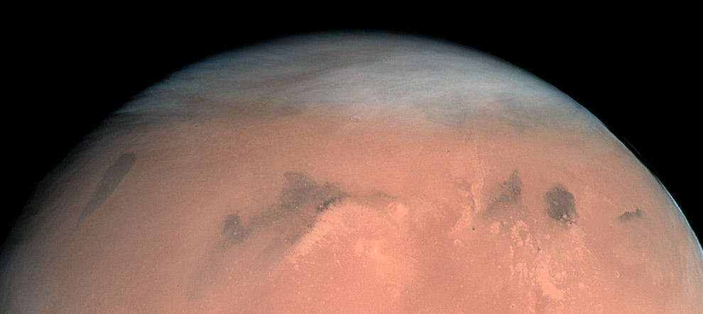
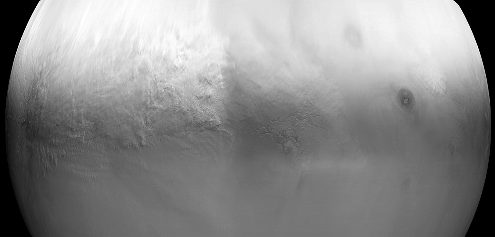
High, wispy clouds cover a large portion of Mars, seen in this, the first true-colour image of Mars generated with the OSIRIS orange (red), green and blue color filters. The image was acquired by an instrument on the ESA's Rosetta probe on Feb. 24, 2007 from a distance of about 240,000 km. Image resolution is about 5 km/pixel. (Credits: ESA © 2007 MPS for OSIRIS Team MPS/UPD/LAM/IAA/RSSD/INTA/UPM/DASP/IDA)
เป็นภาพจากยาน โรเซตตา 24 กุมภาพันธ์ 2550 จากระยะทางราว 240,000 กม.
เป็นภาพจากยาน โรเซตตา 24 กุมภาพันธ์ 2550 จากระยะทางราว 240,000 กม.
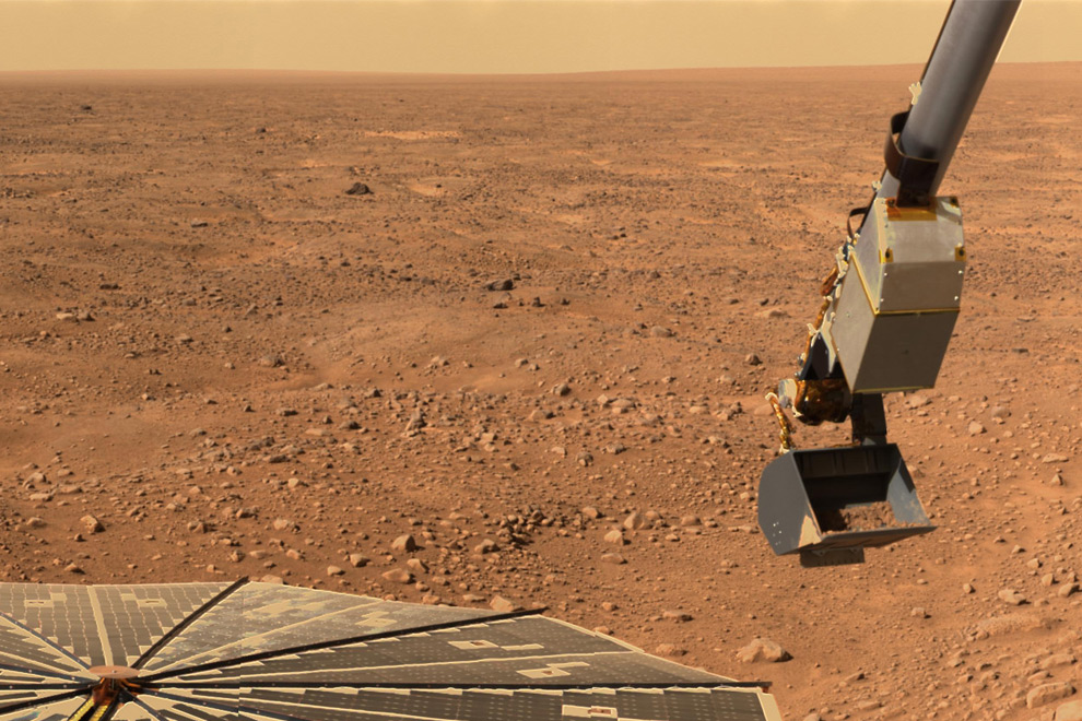
Mars' northern orange sky and horizon, seen by NASA's Phoenix Mars Lander. The lander's solar panel and Robotic Arm with a sample in the scoop are also visible. The image was taken by the lander's Surface Stereo Imager looking west during Phoenix's Sol 16 (June 10, 2008), or the 16th Martian day after landing. The image was taken just before the sample was delivered to the Optical Microscope. (NASA/JPL-Caltech/University of Arizona/Texas A&M University) ภาพจากยาน ฟินิกส์ มาร์ส แลนเดอร์ แสดงให้เห็นท้องฟ้าด้านเหนือของดาวอังคารเป็นสีส้ม
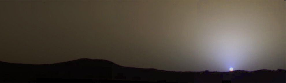
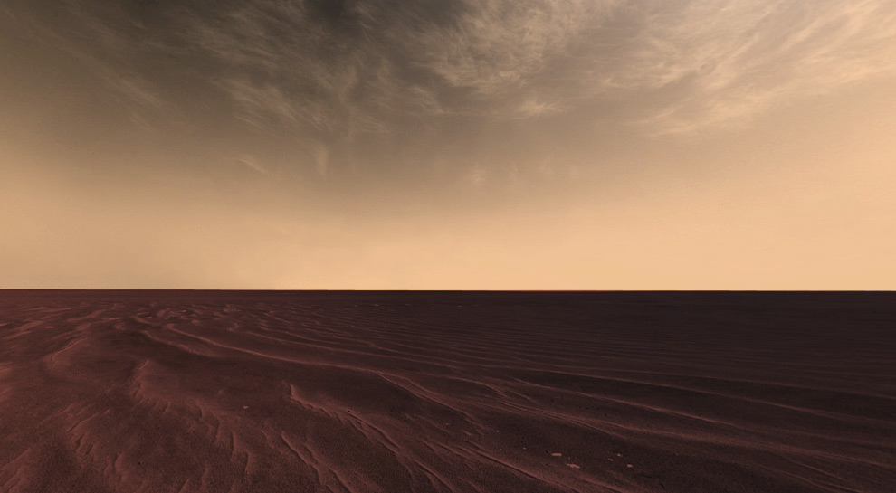
The brownish gray sky at sunset as it would be seen by an observer on Mars - true color mosaic taken by Mars Pathfinder on sol 24 (June 22, 1996) The sky near the sun is a pale blue color. (NASA/JPL) ท้องฟ้าสีน้ำตาลยามตะวันตกดิน ภาพจากยาน พาธฟายเดอร์ 24 มิกุนายน 2539
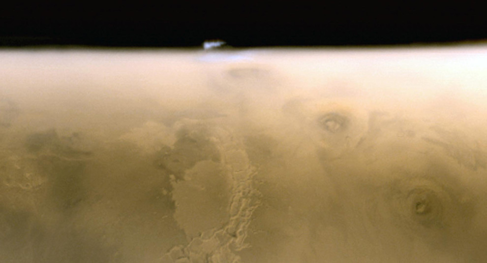
High ice cloud over Mars' limb. This composite of red and blue Mars Global Surveyor (MGS) Mars Orbiter Camera (MOC) images acquired on 6 July 2005 shows an isolated water ice cloud extending more than 30 kilometers (more than 18 miles) above the Martian surface. Clouds such as this are common in late spring over the terrain located southwest of the Arsia Mons volcano. (NASA/JPL/Malin Space Science Systems) เมฆน้ำแข็ง ในปี 2548 แสดงเมฆน้ำแข็งกว่า 30 กม. ลอยเหนือพื้นผิวดาวอังคาร
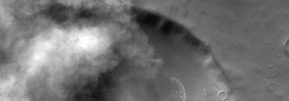
Clouds over crater - the dust storm season in the southern hemisphere of Mars was well underway. This image of an unnamed crater southeast of Hellas Basin shows the encroachment of a storm in the region. Image acquired in 2001 by Mars Odyssey orbiter (17 meter/pixel resolution). (NASA/JPL/ASU) ฤดูพายุฝุ่น ในชั้นบรรยากาศซีกโลกใต้ของดาวอังคาร
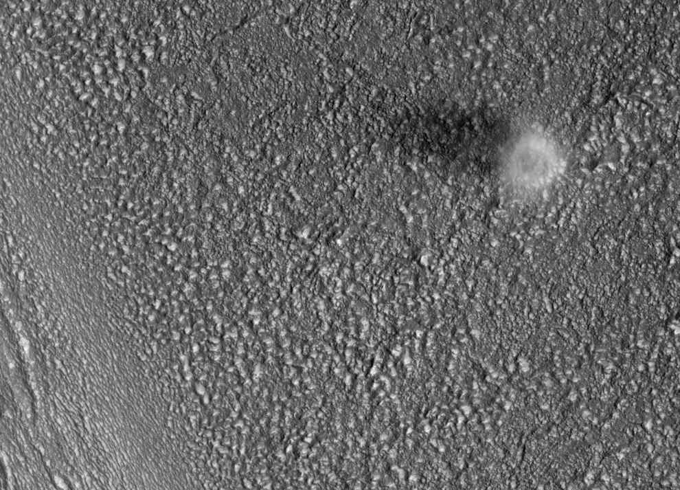
Dust devil from above. This image taken by the Hi-RISE Camera aboard NASA's Mars Reconnaissance Orbiter catches a dust devil blowing across the Martian surface. Dust devils generally form in the afternoon because the sunlight needs sufficient time to warm the surface. When this image was taken, the local time was about 3:08 p.m. The bright material is the dust within the vortex, and a dark shadow cast by the dust devil is visible to the left. The diameter of this dust devil is about 200 meters, but at the surface it is probably much smaller. Based on the length of the shadow in this image, the dust devil is on the order of 500 meters tall. (NASA/JPL/University of Arizona) ลมปิศาจฝุ่น เมื่องมองจากเบื้องบน ภาพนี้ได้จากยานลาดตระเวนดาวอังคาร ที่ชื่อ Mars Reconnaissance Orbiter ลมปิศาจฝุ่นมันจะก่อตัวขึ้นในช่วงบ่าย เพราะแสงอาทิตย์ส่องทำให้อุณหภูมิสูงขึ้น เส้นผ่าศูนย์กลางของลมปีศาจฝุ่นประมาณ 200 เมตร
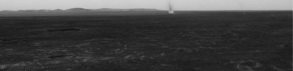
Several dust devils cross a plain in this animation of a series of images acquired by NASA's Mars Rover Spirit in May, 2005. (NASA/JPL-Caltech/Cornell/USGS) ลมปิศาจฝุ่น ถ่ายได้จากยานแล่นสำรวจพื้นผิวดาวอังคาร Mars Rover Spirit ในปี 2548
A well-defined dust devil crosses in front of the camera in this animation of a series of images acquired by NASA's Mars Rover Spirit in May, 2005. (NASA/JPL-Caltech/Cornell/USGS)
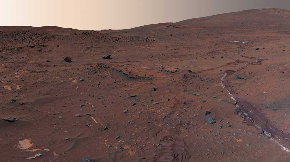
Martian skies seen above a rolling horizon in this image, part of a larger image called the "McMurdo" panorama, taken in the Martian winter of 2006 by NASA's Mars Exploration Rover Spirit. The tracks in the soil are from Spirits wheels as it rolled through the area earlier. (NASA/JPL/Cornell) ท้องฟ้าของดาวอังคารเป็นสีส้ม นี่เป็นช่วงฤดูหนาว ถ่ายโดยยานท่องพื้นผิวดาวอังคาร Mars Exploration Rover Spirit ในปี 2549 ร่องรอยที่เห็นบนพื้นผิวดาวอังคารก็คือ การวิ่งสำรวจของยานนี้นั่นเอง
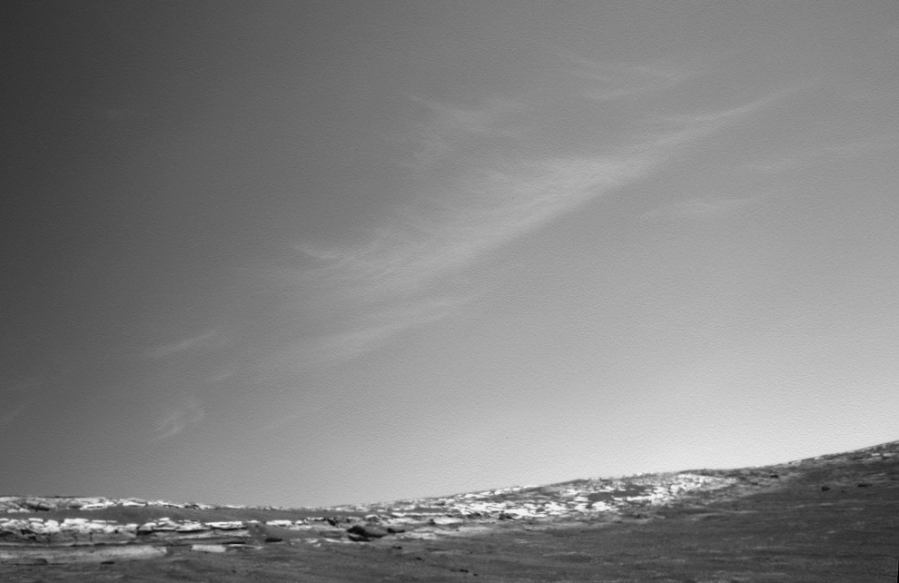
Clouds above the rim of "Endurance Crater" in this image from NASA's Mars Exploration Rover Opportunity. These clouds occur in a region of strong vertical shear. The cloud particles (ice in this martian case) fall out, and get dragged along away from the location where they originally condensed, forming characteristic streamers. Opportunity took this picture with its navigation camera during the rover's 269th martian day (Oct. 26, 2004). (NASA/JPL) เมฆของดาวอังคาร ได้จากยานแล่นสำรวจ Mars Exploration Rover Opportunity
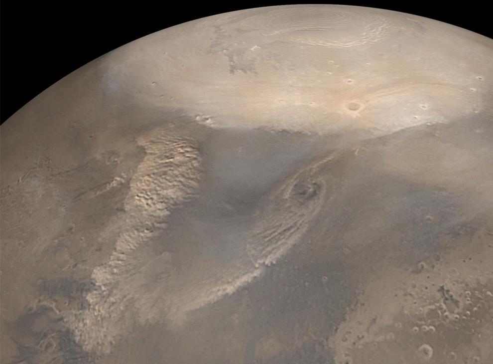
Early Spring Dust Storms at the North Pole of Mars. Early spring typically brings dust storms to northern polar Mars. As the north polar cap begins to thaw, the temperature difference between the cold frost region and recently thawed surface results in swirling winds. The choppy dust clouds of several dust storms are visible in this mosaic of images taken by the Mars Global Surveyor spacecraft in 2002. The white polar cap is frozen carbon dioxide. (NASA/JPL/Malin Space Science Systems) พายุฝุ่นที่ขั้วเหนือของดาวอังคาร ภาพจากยาน Mars Global Surveyor เมื่อปี 2545
An exaggerated color image mosaic of images from NASA's Mars Rover Opportunity. The clouds can be composed of either carbon dioxide ice or water ice, and can move swiftly across the sky. (NASA/JPL/Cornell) ภาพจากยานแล่นสำรวจผิวพื้นดาวอังคาร Mars Rover Opportunity แสดงให้เห็นเมฆที่อาจจะเป็นคาร์บอนได้ออกไซด์ หรือน้ำแข็ง
Large dust storms cover much of Mars' surface in this July, 2001 image, acquired by NASA's Mars Global Surveyor Mars Orbiter Camera. By early July, the martian atmosphere was so hazy that opportunities for high resolution imaging of the planet were very limited. (NASA/JPL/Malin Space Science Systems) ภาพจากกล้องของยานที่โคจรรอบดาวอังคาร Mars Global Surveyor Mars Orbiter ในปี 2544 เป็นภาพพายุฝุ่นขนาดใหญ่
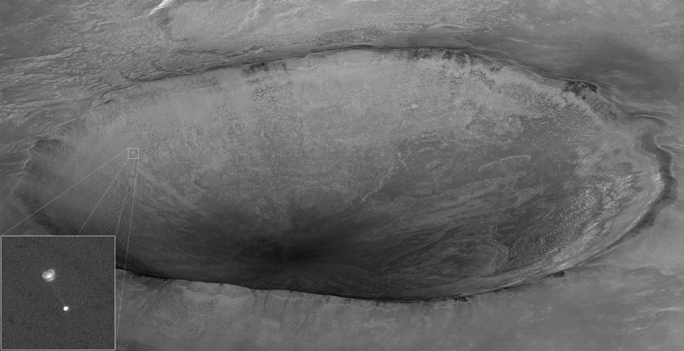
The air is certainly thick enough to fill a parachute. On May 25th, 2008, the HiRISE camera onboard the Mars Reconnaissance Orbiter acquired this dramatic oblique image of the arrival of its sister probe from NASA, the Phoenix Lander, descending on its parachute. Phoenix and its parachute can be barely seen in the larger image with 10 km wide crater informally called "Heimdall" in the background. Although it appears that Phoenix is descending into the crater, it is actually about 20 kilometers in front of the crater. Given the position and pointing angle of MRO, Phoenix is at about 13 km above the surface, just a few seconds after the parachute opened. (NASA/JPL/University of Arizona)
25 พฤษภาคม 2551 อากาศของดาวอังคารยังหนาพอที่จะให้ร่มชูชีพของยาน Phoenix Lander ร่อนลงได้ ภาพนี้ได้จากกล้องของยานโคจรรอบดาวอังคาร Mars Reconnaissance Orbiter ถ่ายไว้ขณะชูชีพกำลังจะแต่พื้นผิวดาวอังคาร 13 กม. ไม่กี่วินาทีหลังจากร่มกาง (จะร่อนลงเร็วเพราะอากาศของดาวอังคารเบาบางมาก)
25 พฤษภาคม 2551 อากาศของดาวอังคารยังหนาพอที่จะให้ร่มชูชีพของยาน Phoenix Lander ร่อนลงได้ ภาพนี้ได้จากกล้องของยานโคจรรอบดาวอังคาร Mars Reconnaissance Orbiter ถ่ายไว้ขณะชูชีพกำลังจะแต่พื้นผิวดาวอังคาร 13 กม. ไม่กี่วินาทีหลังจากร่มกาง (จะร่อนลงเร็วเพราะอากาศของดาวอังคารเบาบางมาก)
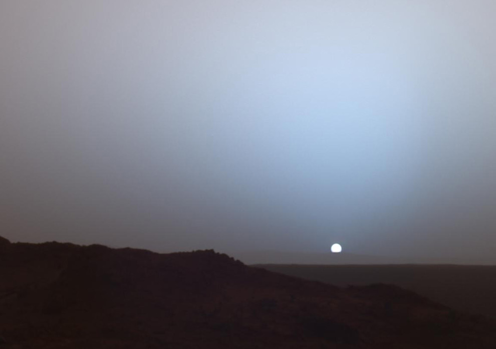
On May 19th, 2005, NASA's Mars Exploration Rover Spirit captured this stunning view as the Sun sank below the rim of Gusev crater on Mars. This Panoramic Camera mosaic was taken around 6:07 in the evening of the rover's 489th martian day, or sol. Spirit was commanded to stay awake briefly after sending that sol's data to the Mars Odyssey orbiter just before sunset. The image is a false color composite, showing the sky similar to what a human would see, but with the colors slightly exaggerated. (NASA/JPL/Texas A&M/Cornell) 19 พฤษภาคม 2548 ยานแล่นสำรวจผิวพื้นดาวอังคาร Mars Exploration Rover Spirit ได้จับภาพนี้เอาไว้ ขณะที่ดวงอาทิตย์กำลังจะลาลับขอบฟ้าบนดาวอังคาร
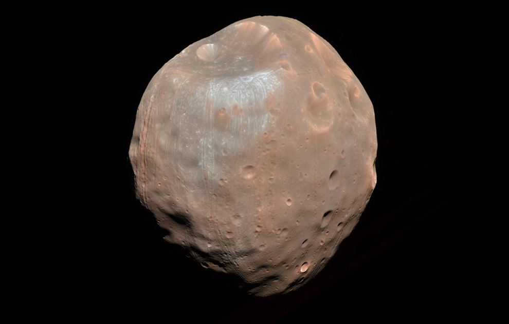
Higher in the Martian skies, we see one of its two moons. The HiRISE camera onboard the Mars Reconnaissance Orbiter acquired this dramatic view of the Martian moon, Phobos, on 23 March 2008, from a distance of 6,800 kilometers. The illuminated part of Phobos is about 21 km across. The most prominent feature is the large impact crater Stickney, in the upper left. With a diameter of 9 km, it is the largest feature on Phobos. (NASA/JPL/University of Arizona) ยานโคจรรอบดาวอังคาร Mars Reconnaissance Orbiter ได้บันทึกภาพดวงจันทร์ โฟบอส Phobos บริวารของดาวอังคารเอาไว้ เมื่อวันที่ 23 มีนาคม 2548 จากระยะทาง 6800 กม.
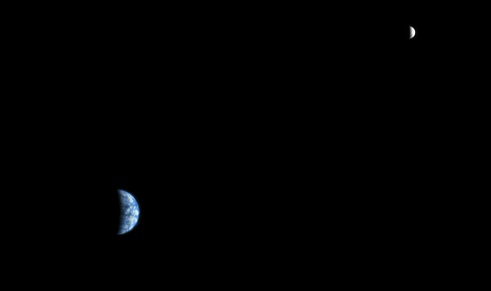
Even higher in the Martian sky, the Earth and Moon hang in space, as seen from Mars. The HiRISE camera onboard the Mars Reconnaissance Orbiter acquired this image at 5:20 a.m. MST on October 3rd, 2007, at a range of 142 million kilometers, while orbiting Mars.
No comments:
Post a Comment